Blog
Keep up to date with the latest from Equator and the HD mapping world

How to Write a Civil Engineering Proposal
How to Write a Civil Engineering Proposal This post will outline the following: what a civil engineering proposal actually is and who creates them; the critical sections that should be included in a civil engineering proposal; and key tips for creating winning engineering proposals. What is a Civil Engineering Proposal A civil engineering proposal is a formal document created by a

Using ArcGIS Pro to Detect Objects Using Deep Learning
Tutorial: Using Equator and ArcGIS Pro to Detect Objects Using Deep Learning In this tutorial, you will learn how to use Equator to source an orthoimage, then use ArcGIS Pro and the tools in the Image Analyst Extension to detect and identify objects through deep learning. Step 1: Source Orthoimage Step 2: Add Orthoimage to ArcGIS Pro Step 3: Classify Objects for Deep Learning

LiDAR vs DEM vs Contours – build smarter surfaces in Civil 3D
User Guide / LiDAR vs DEM vs Contours? LiDAR vs DEM vs Contours? Avoid throwing away data and start building smarter surfaces This article explains the difference between various formats for storing elevation data and how to leverage this information to build smarter surfaces in Civil 3D. Key
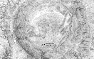
Texas Topographic Map: view and extract detailed topo data
Texas Topographic Map The most detailed topographic map of the State of Texas. Find, build and share high-resolution topographic maps using Equator. Try Now Who is the map for? Texas topography, accessible in Equator, is used by infrastructure design professionals such as: Planners Architects Civil Engineers Flood Analysts Construction Professionals Landscape Designers Try Now What
What is a Civil 3D surface (TIN versus grid)?
User Guide / What is a Civil 3D surface (TIN versus Grid)? What is a Civil 3D surface (TIN versus Grid)? A surface is a 3D view of the land that can represent existing conditions, proposed conditions, or any other scenario involving the group's surface. Understanding what they are and how to work
USGS LiDAR Viewer – Find, view and extract LiDAR instantly
USGS LiDAR Viewer Find, view and extract USGS LiDAR point cloud data instantly using Equator. Go to Viewer Who is the LiDAR Viewer for? The Equator LiDAR viewer is used by professionals such as infrastructure designers and city builders: Planners Architects Civil Engineers Flood Analysts Construction Professionals Landscape Designers Go to Viewer What can I
USGS Point Cloud Sample Gallery in Equator
Gallery: USGS Point Cloud This post includes a gallery of images created in Equator from the USGS point cloud. Data Source: USGS Access in in Equator: Click Here New Mexico Colorado Smoky Mountains Hoover Dike Texas
Montreal LiDAR: view and extract elevation data
Montreal LiDAR View, export, convert and share Montreal LiDAR using Equator in minutes. View Map Equator makes Montreal LiDAR more accessible than ever before Find out why professionals are turning to Equator to unlock the best data and insights. Equator users include: Planners Architects Civil Engineers Flood Analysts Construction Professionals Landscape Designers Try Now

Projected vs. Geographic Coordinate Systems
Projected vs. Geographic Coordinate Systems Thought there was only one type of coordinate system? Think again. There are many different kinds that are used for different purposes. This post will be covering the two kinds that are most useful for surveying: projected and geographic. Projected Coordinate Systems Projected coordinate systems are grids of straight lines that are used
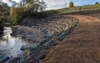
Resilient Consulting Water Resources Case Study
How Resilient Consulting uses Equator to source topographic data for water resources projects Overview Founded in 2018, Resilient Consulting delivers environmental and water resources solutions. Their typical projects range from feasibility studies right through to construction. The team applies the principles of resilience, sustainability and adaptability to everything they do. Their mission is ensuring that community infrastructure is ready to
Texas East LiDAR Project
Texas East LiDAR Project The Texas East LiDAR project was completed for the Texas Water Development Board. Access the data in Equator by clicking below. Access USGS Data The Texas East LiDAR Project The LiDAR survey of Texas East was completed between December 29, 2016 and May 30, 2018. The Texas Water Development Board requested the survey, but other
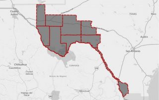
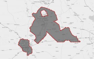
West Texas LiDAR Project
West Texas LiDAR Project The West Texas LiDAR project was completed for the USGS in 2019. The data can be accessed in Equator by clicking below. Access USGS Data The West Texas LiDAR Project The West Texas LiDAR project was completed between February 16 and May 14, 2019. The following counties were included in the survey: Culberson,

The Difference Between GNSS and GPS
The Difference Between GNSS and GPS Most people are familiar Global Positioning System (GPS) as it has probably saved you from getting lost in an unfamiliar place on at least one occasion. GNSS, however, is a term heard much less frequently. It stands for Global Navigation Satellite System, and while it is similar to GPS, there are a few key differences
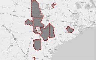
South Texas LiDAR Acquisition Project (FEMA)
South Texas LiDAR Project This page includes a summary of the South Texas FEMA LiDAR Acquisition project. To view or download LiDAR data in Equator right away, click on the button below. Access USGS Data What is the South Texas LiDAR Project? The South Texas LiDAR acquisition project was carried out between January 23, 2018 and February 23, 2019
BC Open Infrastructure Data
BC Municipal Infrastructure Open Data Master List This article contains a list of municipal open data portals in British Columbia, Canada. Each of the open data portals has been reviewed for data sets related to municipal infrastructure, including drainage, water, sanitary and transportation related map layers. If map layers were found in any of these categories, a check mark was provided to
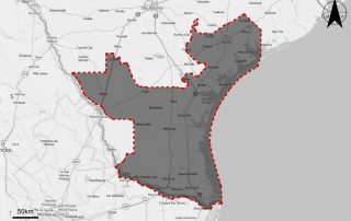
Texas Central LiDAR Project (San Antonio and La Grange)
Texas Central LiDAR Project The Texas Central LiDAR Project covers San Antonio and La Grange. Data is provided and managed by the USGS. Texas LiDAR data can be accessed on-demand in Equator. Access USGS Data The Texas Central LiDAR Project The Texas Central LiDAR Project was completed between January 20, 2017 and March 22, 2017. There were various stakeholders
Texas Hurricane Harvey LiDAR Acquisition Project (USGS)
Texas Hurricane Harvey LiDAR Project This page includes a summary of the Texas Hurricane Harvey LiDAR Acquisition project, completed for USGS. To view or download LiDAR data in Equator now, click the link below. Access USGS Data The Texas Hurricane LiDAR Project LiDAR in Texas was acquired between January 4, 2019 and February 20, 2019 in 69
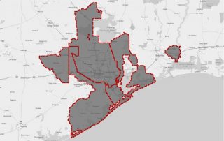
Texas Coastal LiDAR Project (Houston and Surrounds)
Texas Coastal LiDAR Project This page includes a summary of the Texas Coastal LiDAR project, completed for the Texas Water Development Board. You can read more about the data, or access it right away by clicking on the link below. Access USGS Data The Texas Coastal LiDAR Project The Texas Coastal LiDAR project was completed between January
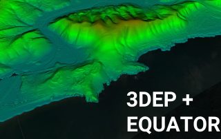
Equator Launches 3DEP USGS Topographic Maps
Equator Launches 3DEP High-Resolution USGS Topographic Maps Equator provides unprecedented access to inches of accuracy, in a user-friendly online design platform. Last Updated: November 7, 2021 Launch Equator Equator has recently launched support for high-resolution USGS topographic maps, provided through the 3D Elevation Program (3DEP). The program aims to collect Quality Level 1, 2 and 3 LiDAR data, which
How to create a Civil 3D surface from a contour shapefile?
User Guide / How to create a Civil 3D surface from a contour shapefile? How to create a Civil 3D surface from a contour shapefile? This tutorial will show you one of the fastest and easiest ways to create a surface in Civil 3D from GIS data, specifically contours in shapefile format. Check out

Key Mapping and GIS Terms
Key Mapping and GIS Terms: A Clear and Concise Glossary Updated 2023-08-23 Terms related to mapping and GIS can be confusing, especially if you are new to the topic. Understanding these terms is essential to realizing just how powerful a tool mapping can be. Once you understand these key words and phrases, you can use a piece of software to its full potential, or complete
Open Cities Index Results 2019 (Canada)
Improving Canada's Open Data Access For the Future PSD’s Open Cities Index is Canada’s first standard study for municipal open data initiatives, making it easy to find information on data availability by municipality. This study has been running for four years, and shows promising results with improved overall scores each year. Apart from knowing which cities are at the top of the list
New to QGIS? Why not start here instead
The next generation of GIS tools: Create professional maps in minutes. Introduction GIS software is complicated. That’s no secret. If it weren’t, you wouldn’t require years of specialized training in this hybrid Computer Science-Geography-Design field. Nearly every industry relies on maps in some shape or form (pun intended) with varying degrees of complexity required. In most cases the

A Closer Look at Ontario’s Digital Terrain Model
An Increase in Lidar Accuracy and what that means for Civil Engineers The Ontario Digital Terrain model represents a gridded raster product (bare-earth terrain) originating from a classified Lidar point cloud. Often referred to as OMAFRA Lidar (or DTM), this Lidar data is hydro-flattened using water body breaklines. Hydro-flattened data means that any water surfaces you see on the model appear the same as
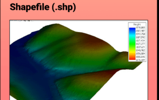
Creating a 3D Mesh from a Contour Shapefile in MicroStation
Tutorial: Creating a 3D Mesh from a Contour Shapefile in Bentley MicroStation In this tutorial, learn how to create a 3D surface mesh in MicroStation from a topography or contour shapefile (.shp file) exported from Equator Step 1: Source your topography data Step 2: Import shapefile into MicroStation and create 3D mesh Download Topography Shapefiles Here Create a 3D Mesh in