LiDAR Quality Levels
What is LiDAR data?
LiDAR is a radar technology that uses light to measure distances. It is often used in conjunction with other remote sensing technologies, such as GPS and aerial photography. There are a number of commercial LiDAR devices available on the market, and the technology is becoming more and more popular among engineers and students. LiDAR data is applied in a variety of important projects, such as: construction, disaster relief, avoidance systems for aircraft, etc. The nature of the various applications for this data implies that a level of quality must be maintained, hence the Quality Levels (QLs) for LiDAR data.

Quality Levels for LiDAR
The Quality Levels (QLs) for LiDAR data are defined in accordance with the more relevant features of a LiDAR data set. As of now, there are two major features used to classify LiDAR to a Quality Level, and those are: point density/nominal pulse spacing and vertical accuracy.


Point Density
Point density – in simple terms – refers to the average number of points in a particular area of interest. Generally, it is evaluated for every one square meter, and is therefore commonly expressed in points per square meter (or ppm2 or pts/m2).
Nominal Pulse Spacing
Another consideration is Nominal Pulse Spacing, which is simply the average distance between two points.
Vertical Accuracy
Vertical accuracy is an important specification for LiDAR systems. It specifies the maximum allowable deviation of the reported elevation from the actual elevation of a point. Vertical accuracy is expressed as the root mean square error (RMSE).
LiDAR Quality Level (QL) Requirements
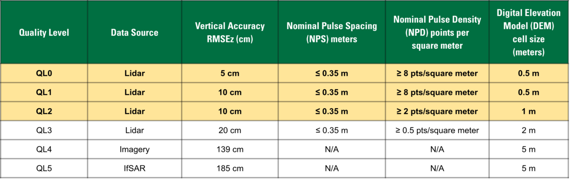
(Source: USGS 3DEP Table 1)
Above is a LiDAR Quality Level (QL) requirements chart with the criteria that has been previously discussed. The quality levels here range from 0 to 5, including data sources such as Imagery and IfSAR.


