Blog
Keep up to date with the latest from Equator and the HD mapping world
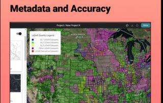
Discover the HIDDEN Accuracy of Your LiDAR Data
Discover the HIDDEN Accuracy of Your LiDAR Data Mastering LiDAR Quality: A Quick Guide to Understanding Metadata and Accuracy It all starts with the USGS LiDAR Quality Levels This legend appears on Equator's interface when you turn on the Elevation Products. But what does it mean? The varying quality levels (QL) are defined by the

Create a Surface in AutoCAD Civil 3D
Tutorial: Create a Surface in Civil 3D Use Equator to source a Contour Drawing File (.dwg) that can easily be brought into AutoCAD Civil 3D to create a surface. Step 1: Source Your Contour Data Step 2: Create a TIN Surface Step 3: Choose Your Surface Style Find Contour Data for your next project Step 1 Source Your

How to Calculate the Slope on a Topographic Map using Contour Lines
How to Calculate the Slope on a Topographic Map using Contour Lines Use Equator to Determine the Slope or Gradient on a Contour Map By studying topographic maps, we can gain invaluable insight into the Earth's terrain and better understand the complex landscapes that shape our environment. The analysis of contour lines on these maps allows us to determine the slope or gradient

Create a 3D Terrain in Rhino From Contours
Tutorial: Create a 3D Terrain in Rhino From Contours Learn how to create a topographic surface using an AutoCAD Drawing File in 3 easy steps: 1. Source Contour Data 2. Import Contour Data into Rhino 3. Run the Patch Command to create a 3D Surface Find Contours for your site Step 1 Source

How Steve Brings His Favorite Places to Life in Vivid 3D Using Topographic Data from Equator
How Steve Brings His Favorite Places to Life in Vivid 3D Using Topographic Data from Equator About Steve Moseley: Civil Engineer, Artist, Builder Location: Waukee, Iowa, USA Steve creating the wood blank that he will carve the terrain model from Meet Steve: a civil engineer by day and a DIY enthusiast by night Steve Moseley

The Benefits of Map Making
The Benefits of Map Making Maps have been an essential tool for humans throughout history. From ancient civilizations to modern times, map making has played a crucial role in helping us navigate, understand, and interpret the world around us. The benefits of map making are numerous, and they extend far beyond simple navigation. Below, we will explore some of the key advantages of map

How to Create a Study Area Map
Tutorial: How to Create a Study Area Map Learn how to create a Study Area Map in Equator for Environmental Assessments, Urban Planning, or Market Research In various fields, including environmental assessment, urban planning, and market research, study area maps play a crucial role in understanding and analyzing specific geographic regions. Use Equator to Make a Study Area Map Study Area Map

How to Create Contours in QGIS from a DEM
How to Create Contours in QGIS from a DEM: Download DEM file Open the DEM in QGIS Run the contours process Step 1 Download DEM File Note: In this example, we use a DEM exported from Equator. 1. Visit Equator Studios and go to the Data Menu 2. Select Digital Elevation Model from the left-hand Data menu 3. Select

GIS in Transportation: The Future is Here
GIS for Transportation Introduction GIS, or geographic information systems, is a powerful tool that is increasingly being used in the transportation sector. GIS enables the analysis and visualization of spatial data, allowing for the integration of geographical elements into transportation planning and management. The benefits of using GIS in transportation are numerous, including improved efficiency, safety, and sustainability. Examples of how GIS is used in

How to Import a Point Cloud into QGIS
How to Import a LiDAR Point Cloud (.LAZ) into QGIS QGIS version 3.25 (released in 2021) and subsequent versions has a feature that allows you to import LiDAR point clouds (LAZ files) into QGIS without needing a third party extension. Definitions Source LiDAR Point Cloud Data Import LAZ Into QGIS View as a Map Based on Attributes (i.e. Height, Classification, and Eye Dome Lighting)

Create Topography in Revit
Create Topography in Revit Learn how to create a 3D Terrain in Revit using an AutoCAD (.dwg) file Background: What is Revit? Who uses Revit? Tutorial Step 1: Source Topographic Data Tutorial Step 2: Link AutoCAD (.dwg) File to Revit Tutorial Step 3: Create Toposurface in Revit Tutorial Extra: Label Contour Lines in Revit Background:

Environmental Impact Assessments: Your Guide to Responsible Development
Environmental Impact Assessments EIAs: Your guide to responsible development Did you know that the concept of environmental impact assessments (EIAs) dates back to the 1960s? What is an Environmental Impact Assessment (EIA)? An environmental impact assessment (EIA) assesses the potential social, environmental, and economic impacts of a potential project. The purpose of an EIA is

The Importance of Land Surveying Accuracy: Why Every Inch Counts
Land Surveying Accuracy Introduction Land surveying is a crucial field that involves the measurement and mapping of land and other physical features. Accurate land surveying is essential for a variety of purposes, such as determining property boundaries, creating topographic maps, and supporting the construction of buildings and infrastructure. The role of accuracy in land surveying cannot be overstated. Factors that affect land surveying accuracy There
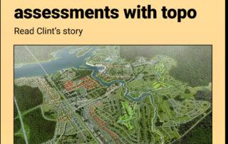
How Clint Speeds Up Drainage Assessments and Real Estate Decisions with Better Topo Data
How Clint Speeds Up Drainage Assessments and Real Estate Decisions with Better Topo Data About Clint Karsetter: Principal, Owner Company: CK Civil Engineering LLC Location: Fayetteville, Arkansas Meet Clint, Owner and Chief Engineer of CK Civil Engineering Clint, the Owner and Chief Engineer of CK Civil Engineering LLC, runs a civil engineering firm serving commercial

How to convert Lat Long to UTM
How to convert Lat Long to UTM? It is possible to convert geographic coordinates in latitude and longitude (lat/long) to Universal Transverse Mercator (UTM) coordinates. UTM is a standardized coordinate system that is used to locate positions on the Earth's surface. To convert lat/long coordinates to UTM, you will need to know the longitude of the central meridian for the UTM
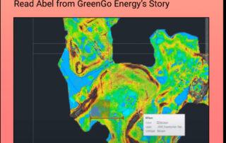
How Abel cut his proposal costs and sped up his projects with Equator
How Abel cut his proposal costs and sped up his projects with Equator About Abel: Senior Civil Engineer Location: Mexico City, Mexico Meet Abel Abel is a senior civil engineer based in Mexico. He works for a renewable energy company in Demark that specializes in solar and wind energy. His role is to do preliminary

VVA (Vegetated Vertical Accuracy) vs NVVA (Non-Vegetated Vertical Accuracy)
What is Vegetated Vertical Accuracy (VVA)? Vegetated Vertical Accuracy (VVA) is a measure of the accuracy of a digital elevation model (DEM) in areas where the land surface is covered by vegetation, such as forests or grasslands. It is expressed as the difference between the true elevation of the ground surface and the elevation that is recorded in the DEM. The

What is Land Surveying?
What is land surveying? Land surveying is the practice of measuring and mapping the land surface. Surveying is used to determine the precise boundaries of a piece of land, as well as the location of natural and man-made features on the land. Surveying is typically performed by professional land surveyors, who use specialized equipment, such as total stations and GPS receivers,

Equipment Required to Complete a Topographic Survey
What Equipment is Required to Complete a Topographic Survey? A topographic survey involves collecting feature data for a plot of land, such as contours, elevations, and other physical characteristics. There are a variety of tools and equipment that are commonly used to complete a topographic survey, including: Total station: A total station is a surveying instrument that uses electronic distance measurement (EDM) to measure distances

What is NTRIP?
What is NTRIP? NTRIP (Network Transport of RTCM via Internet Protocol) is a protocol for transmitting Real Time Kinematic (RTK) GPS data over the Internet. RTK GPS is a high-precision GPS technology that can provide accuracy down to a few centimeters. NTRIP is used to transmit RTK GPS data from a base station to a mobile receiver, allowing the mobile receiver

Everything You Need to Know about Drone Surveying
How to Perform a Drone Land Survey? A drone land survey involves using an unmanned aerial vehicle (UAV) or drone to collect data about the land surface for the purpose of creating maps and models. Here is a general outline of the steps involved in performing a drone land survey: 1. Plan the survey: Determine the area to be surveyed, the

LiDAR Myths
LiDAR Myths Exposed Six Common Myths and Misconceptions about LiDAR Collection and Data Explained Myth 1: More points are always better In reality, it depends! More points mean higher cost, slower processing and larger datasets so it’s important to know what is required for job and weigh the factors! When are more points typically better: In a densely forested area

How to Open a KMZ file in Google Earth
How to open a KMZ file in Google Earth Opening KML files is very simple! Follow this short article to learn how. Opening a KMZ file Open Google Earth. In the top menu, go to File > Open , and select the KMZ file you want to view. Google Earth will zoom to the location of the KMZ

How to Import an STL file into Blender
User Guide / Import STL into Blender How to Import an STL file into Blender In this tutorial, we will walk you through exporting a Printable Mesh file from Equator, as well as importing it into Blender. To begin, find an area with that you would like to create a

LiDAR Data Processing: The Game-Changing Technology That’s Transforming Industries
LiDAR Data Processing Introduction LiDAR (Light Detection and Ranging) is a remote sensing technology that uses lasers to measure distances and generate high-resolution 3D maps of the Earth's surface. It works by emitting laser pulses and measuring the time it takes for the pulses to return to the LiDAR sensor after reflecting off of objects in the environment. By analyzing the returning laser pulses, LiDAR